
Tag: Spatial Data Analytics

No Time To Die

By Nicolas Lenz, Litix GmbH

The organization of the 11th meeting of the Spatial Data Analytics Expert Group included some unexpected twists. After postponing the original meeting in September, we also had to switch to an online format at short notice on the new date. Although the excitement couldn’t quite compete with a real agent movie, we were at least pleased that we could finally welcome a large number of participants.

The real excitement came from the announced contents. Dr. Joachim Steinwendner from FFHS had offered to host the meeting and had prepared a program with the topic GIS and Health. The two announced talks were titled after Bond movies.They addressed the interface between GIS and Health, once from the pharmacological point of view of and once from the perspective of geoinformatics.

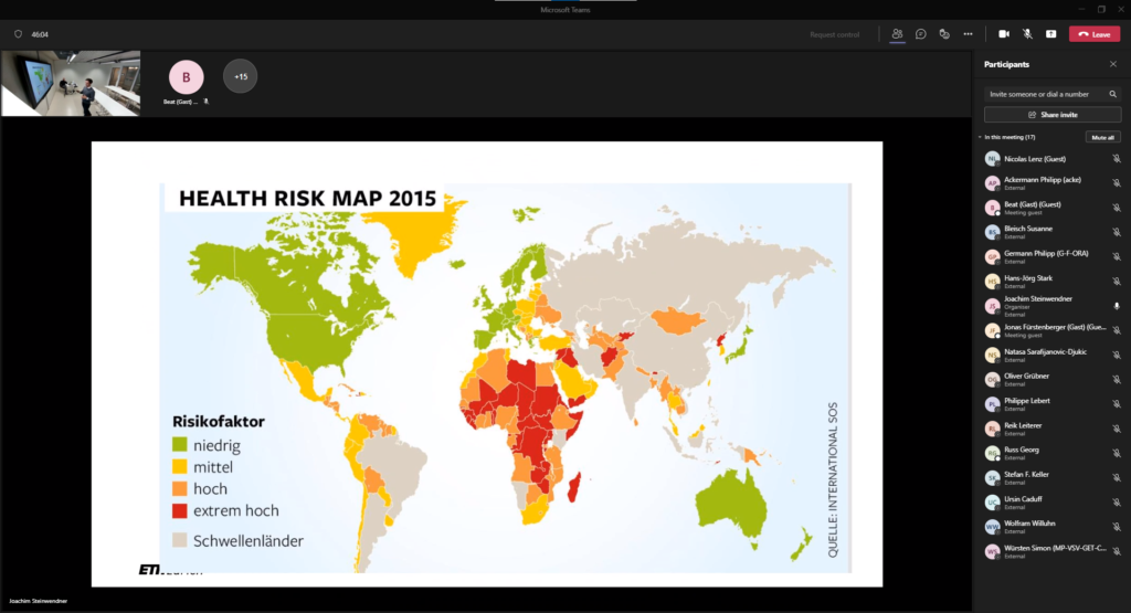
PD Dr. Stefan Weiler focused on the first view. In his talk “On Her Majesty’s Secret Service” he presented the role of geodata in medicine with numerous illustrations (e.g. the Corona dashboards). Joachim Steinwendner then changed the perspective in his talk “The World Is Not Enough”. He asked the audience to imagine a GIS in which the coordinate system did not map the world, but rather the human body.
The meeting ended in an informal exchange under wonder.me. Plans were made for future collaborations or at least for the next visit to the cinema.

The Art of Data Fusion

By Nicolas Lenz (Litix), Stefan Keller (OST) and Reik Leiterer (ExoLabs)

Geodata are used in various industries and academic fields and often have to meet specific requirements in order to be used, for example in terms of geometry, recording time point or semantics. But often different geodata sets have similar geometric properties but different semantics or are captured at different times – or vice versa. Accordingly, the added value arises when your data sources start to «talk to each other», connection points between the data are used or possible gaps can be filled. In this context, there is a multitude of technical terms, which are sometimes used differently depending on the subject area, sometimes are used synonymously and sometimes are used inappropriately in their terminology – so you will read about «append», «merge», «relate», «link», «connect», «join», «combine», or «fuse», just to mention a few.

In the last meeting of the Spatial Data Expert Group on the 4th of November, this topic was presented and discussed, and the challenges and potential of the concept were highlighted. This included a critical examination of the semantic classification as well as the presentation of various possible applications in research and industry. Our host was the UZH Space Hub at the University of Zurich, represented by Dr. Claudia Röösli.

Representation of individual tree characteristics based on multi-temporal airborne 3D-LiDAR data, in situ measurements, and multi-spectral satellite data. Fuses data – or not?

So, what is Data Fusion – with a strong focus on spatial data? For some, it means more a list of different data sets, with a narrative relating one data set to the next. For others, it means visualizing different data sources on the same graph to spot trends, dynamics, or relations. In the spatial domain, the basic concept of data fusion is often the extraction of the best-fit geometry data as well as the most suitable semantic data and acquisition times from existing datasets.

The keynote was given by Dr. André Bruggmann, Co-CEO, Data Scientist and Geospatial Solutions Expert at Crosswind GmbH. Under the motto “Unlock the Where.”, he presented how data fusion techniques help customers gain new insights, from (spatial) visualizations and web applications to facilitate strategic business decisions (e.g., selection of optimal point of sale locations). In addition, he presented a project where data fusion techniques are applied to make detailed and future-oriented statements about the assertiveness of e-mobility and identify relevant trends for the automotive industry.

Dr. André Bruggmann from Crosswind – “Unlock the Where”

These inputs led to an exciting discussion between the experts present – not only on the technical implementations presented, but also regarding the potential for optimisation and possible future cooperation. This is exactly how the initiators of the event had envisioned it – an open and inspiring exchange in line with the basic idea of open innovation.

Are you also interested in spatial data and its applications? Then come to the next expert group meeting on 15th of December on the topic of GIS and Health, hosted by Dr. Joachim Steinwendner from FFHS.

Expert Group Meeting – Spatial Data

Geodata are used in various industries and academic fields and often have to meet specific requirements in order to be used, for example in terms of geometry, recording time point or semantics. But often different geodata sets have similar geometric properties but different semantics or are captured at different times – or vice versa. The basic concept of data fusion is the extraction of the best-fit geometry data as well as the most suitable semantic data and acquisition times from existing datasets. The extracted data features are then fused into a new data set, ideally adding synergistic value. In this expert group meeting, different examples of data fusion will be presented, and possible further application options will be discussed.

The host of this meeting is the UZH Space Hub and the Swiss National Point of Contact for Satellite Images (NPOC), represented by Dr. Claudia Röösli. The meeting will be held at the Irchel campus of the University of Zurich.

Please use the form below to register for the event.

Webinar: Geodatenschätze und die vielfältige Nutzung

⇒ Zu obigen und weiteren Webinaren werden auf www.geosummit.ch schrittweise zusätzliche Angaben zu Inhalten und Referent*Innen aufgeschaltet. Es werden auch noch weitere Webinare dazukommen.

Eine Registrierung ist erforderlich, damit der Zutritt ins Webinar gewährt wird.
Registrierung

Dank der Unterstützung von Innosuisse und den Gold-, Silber- und Bronzepartnern sowie Kongresspartner können die Webinare im 2021 kostenlos angeboten werden. Möchten Sie die Leistungen des Vereins GEOSummit anerkennen, so können Sie einen Ihnen beliebigen Betrag überweisen. Die Bankangaben finden Sie auf der Buchungsbestätigung. Die freiwilligen Beiträge werden für die Organisation des nächsten GEOSummit – hoffentlich wieder «analog» durchgeführt – eingesetzt.

Unterstützer: Innosuisse – Schweizer Agentur für Innovationsförderung

Die Goldpartner sind: Hexagon Schweiz AG, ESRI SCHWEIZ AG, GEOCOM by VERTIGIS, EXOLABS
Die Silberpartner sind: DeltaOffice, Schutz vor Naturgefahren, BENNETBILL, CENTRE PATRONAL, INSER, viadiversa
Die Bronzepartner sind: iNovitas und digitalswitzerland
Die Kongresspartner sind: SOGI, GEOSUISSE, IGS, KGK, GKG, FGS, SGK, SGPF und FHNW.

Einen herzlichen Dank an alle Partner.
Partner GEOSummit

Registrieren Sie sich für die Webinare! Ohne Registrierung gibt es keinen Zutritt zu den Webinaren. Das Organisationskomitee freut sich, Sie im digitalen Raum begrüssen zu dürfen.

Freundliche Grüsse und beste Gesundheit wünscht
Verein GEOSummit

Pol Budmiger, Präsident
Thomas Meyer, Geschäftsführer.

Spatial Data Analytics at the
#wetechtogether conference, 02.10.2021

By Nicolas Lenz, Litix Applied Data Science

Spatial Data was a workshop topic at the #wetechtogether conference which took place on October 2. The data innovation alliance, its member Litix and WiMLDS Zurich sponsored and organized two workshops entitled “Jump into Geodata”. The participants learned how to access Swiss geoservices with Python and how to use them for the presentation and analysis of geodata. We would like to thank the participants for their attendance and the lively discussions in the workshops. We hope that this will lead to new innovative geospatial projects in the future!

Innovative ideas around geodata are indeed welcome, since Spatial Data Analytics is one of four focus topics in the Databooster initiative. Project ideas related to geospatial data have increased chances of receiving Databooster support!

Being part of the #wetechtogether conference was a great experience for data innovation alliance and Litix. We support the main goal of the conference to empower people to bring more diversity into tech. We are already looking forward to the 2022 edition!

ONLINE – Expert Group Meeting – Spatial Data

The next Expert Group meeting of Spatial Data will be in December.
The meeting will by physical in the Gleisarena Zürich! The meeting has been changed to being online! A Teams-link will be sent to all registered participants.

Main topic of the discussion will be GIS and health.

With the earth as reference object (“geospatial”):
On Her Majesty’s Secret Service – Die Bedeutung von Raum und Zeit aus pharmakologischer Sicht
Talk by PD Dr. med Stefan Weiler, EMBA
Experte European Medicines Agency
Senior Researcher ETH Zürich Pharmakoepidemiologie

With the human body as reference object:
The World Is Not Enough – Die Bedeutung von Raum und Zeit in der Klinik
Talk by Dr. Joachim Steinwendner, MSc.
Forschungsfeldleiter “GeoHealth”, FFHS
Dozent ETH, CAS RIS/GIS

  • Open discussion
  • Chat in wonder.me

Please register using the form below.

Webinar: Geokoordination

⇒ Zu obigen und weiteren Webinaren werden auf www.geosummit.ch schrittweise zusätzliche Angaben zu Inhalten und Referent*Innen aufgeschaltet. Es werden auch noch weitere Webinare dazukommen.

Eine Registrierung ist erforderlich, damit der Zutritt ins Webinar gewährt wird.
⇒ Registrierung

Dank der Unterstützung von Innosuisse und den Gold-, Silber- und Bronzepartnern sowie Kongresspartner können die Webinare im 2021 kostenlos angeboten werden. Möchten Sie die Leistungen des Vereins GEOSummit anerkennen, so können Sie einen Ihnen beliebigen Betrag überweisen. Die Bankangaben finden Sie auf der Buchungsbestätigung. Die freiwilligen Beiträge werden für die Organisation des nächsten GEOSummit – hoffentlich wieder «analog» durchgeführt – eingesetzt.

Unterstützer: Innosuisse – Schweizer Agentur für Innovationsförderung

Die Goldpartner sind: Hexagon Schweiz AG, ESRI SCHWEIZ AG, GEOCOM by VERTIGIS, EXOLABS
Die Silberpartner sind:  DeltaOffice, Schutz vor Naturgefahren, BENNETBILL, CENTRE PATRONAL, INSER, viadiversa
Die Bronzepartner sind:  iNovitas und digitalswitzerland
Die Kongresspartner sind: SOGI, GEOSUISSE, IGS, KGK, GKG, FGS, SGK, SGPF und FHNW.

Einen herzlichen Dank an alle Partner.
⇒ Partner GEOSummit

Registrieren Sie sich für die Webinare! Ohne Registrierung gibt es keinen Zutritt zu den Webinaren. Das Organisationskomitee freut sich, Sie im digitalen Raum begrüssen zu dürfen.

Freundliche Grüsse und beste Gesundheit wünscht
Verein GEOSummit

Pol Budmiger, Präsident
Thomas Meyer, Geschäftsführer.

Webinar: Kataster der Zukunft

⇒ Zu obigen und weiteren Webinaren werden auf www.geosummit.ch schrittweise zusätzliche Angaben zu Inhalten und Referent*Innen aufgeschaltet. Es werden auch noch weitere Webinare dazukommen.

Eine Registrierung ist erforderlich, damit der Zutritt ins Webinar gewährt wird.
⇒ Registrierung

Dank der Unterstützung von Innosuisse und den Gold-, Silber- und Bronzepartnern sowie Kongresspartner können die Webinare im 2021 kostenlos angeboten werden. Möchten Sie die Leistungen des Vereins GEOSummit anerkennen, so können Sie einen Ihnen beliebigen Betrag überweisen. Die Bankangaben finden Sie auf der Buchungsbestätigung. Die freiwilligen Beiträge werden für die Organisation des nächsten GEOSummit – hoffentlich wieder «analog» durchgeführt – eingesetzt.

Unterstützer: Innosuisse – Schweizer Agentur für Innovationsförderung

Die Goldpartner sind: Hexagon Schweiz AG, ESRI SCHWEIZ AG, GEOCOM by VERTIGIS, EXOLABS
Die Silberpartner sind:  DeltaOffice, Schutz vor Naturgefahren, BENNETBILL, CENTRE PATRONAL, INSER, viadiversa
Die Bronzepartner sind:  iNovitas und digitalswitzerland
Die Kongresspartner sind: SOGI, GEOSUISSE, IGS, KGK, GKG, FGS, SGK, SGPF und FHNW.

Einen herzlichen Dank an alle Partner.
⇒ Partner GEOSummit

Registrieren Sie sich für die Webinare! Ohne Registrierung gibt es keinen Zutritt zu den Webinaren. Das Organisationskomitee freut sich, Sie im digitalen Raum begrüssen zu dürfen.

Freundliche Grüsse und beste Gesundheit wünscht
Verein GEOSummit

Pol Budmiger, Präsident
Thomas Meyer, Geschäftsführer.

Webinar: Geo-Visualisierung – Unendlich viele Möglichkeiten

⇒ Zu obigen und weiteren Webinaren werden auf www.geosummit.ch schrittweise zusätzliche Angaben zu Inhalten und Referent*Innen aufgeschaltet. Es werden auch noch weitere Webinare dazukommen.

Eine Registrierung ist erforderlich, damit der Zutritt ins Webinar gewährt wird.
⇒ Registrierung

Dank der Unterstützung von Innosuisse und den Gold-, Silber- und Bronzepartnern sowie Kongresspartner können die Webinare im 2021 kostenlos angeboten werden. Möchten Sie die Leistungen des Vereins GEOSummit anerkennen, so können Sie einen Ihnen beliebigen Betrag überweisen. Die Bankangaben finden Sie auf der Buchungsbestätigung. Die freiwilligen Beiträge werden für die Organisation des nächsten GEOSummit – hoffentlich wieder «analog» durchgeführt – eingesetzt.

Unterstützer: Innosuisse – Schweizer Agentur für Innovationsförderung

Die Goldpartner sind: Hexagon Schweiz AG, ESRI SCHWEIZ AG, GEOCOM by VERTIGIS, EXOLABS
Die Silberpartner sind:  DeltaOffice, Schutz vor Naturgefahren, BENNETBILL, CENTRE PATRONAL, INSER, viadiversa
Die Bronzepartner sind:  iNovitas und digitalswitzerland
Die Kongresspartner sind: SOGI, GEOSUISSE, IGS, KGK, GKG, FGS, SGK, SGPF und FHNW.

Einen herzlichen Dank an alle Partner.
⇒ Partner GEOSummit

Registrieren Sie sich für die Webinare! Ohne Registrierung gibt es keinen Zutritt zu den Webinaren. Das Organisationskomitee freut sich, Sie im digitalen Raum begrüssen zu dürfen.

Freundliche Grüsse und beste Gesundheit wünscht
Verein GEOSummit

Pol Budmiger, Präsident
Thomas Meyer, Geschäftsführer.